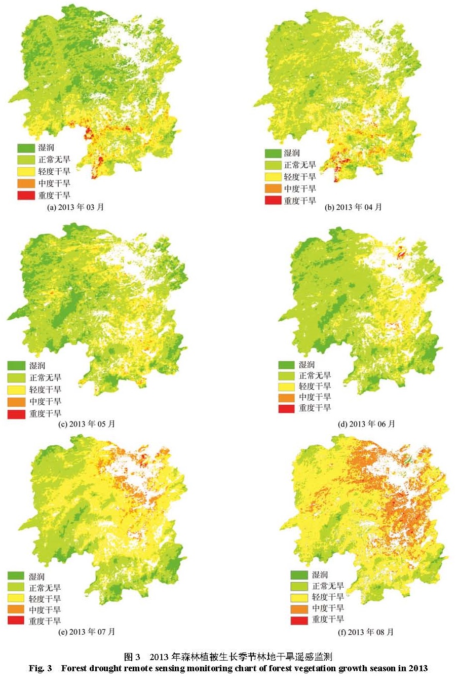
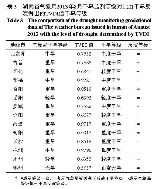
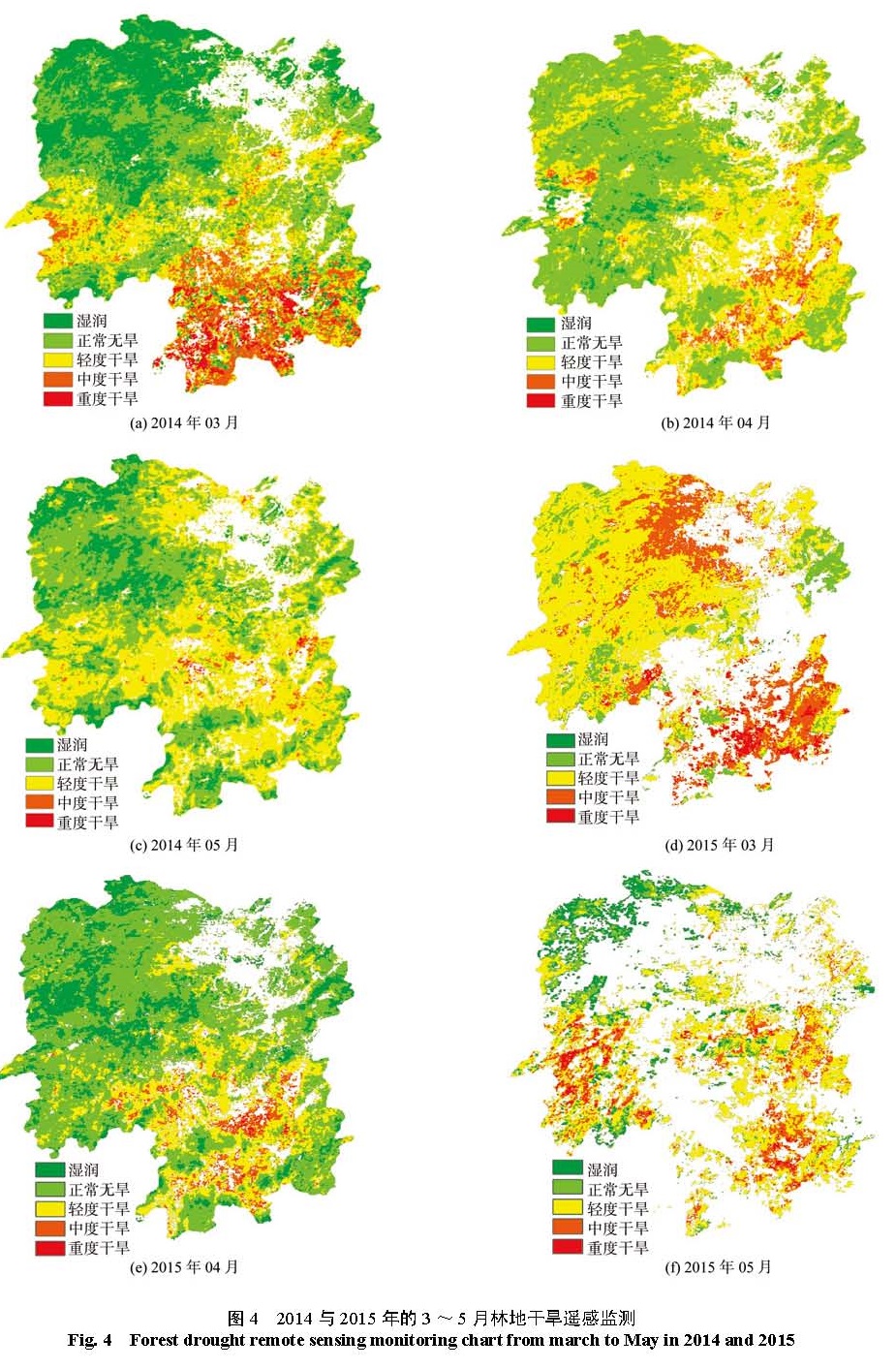
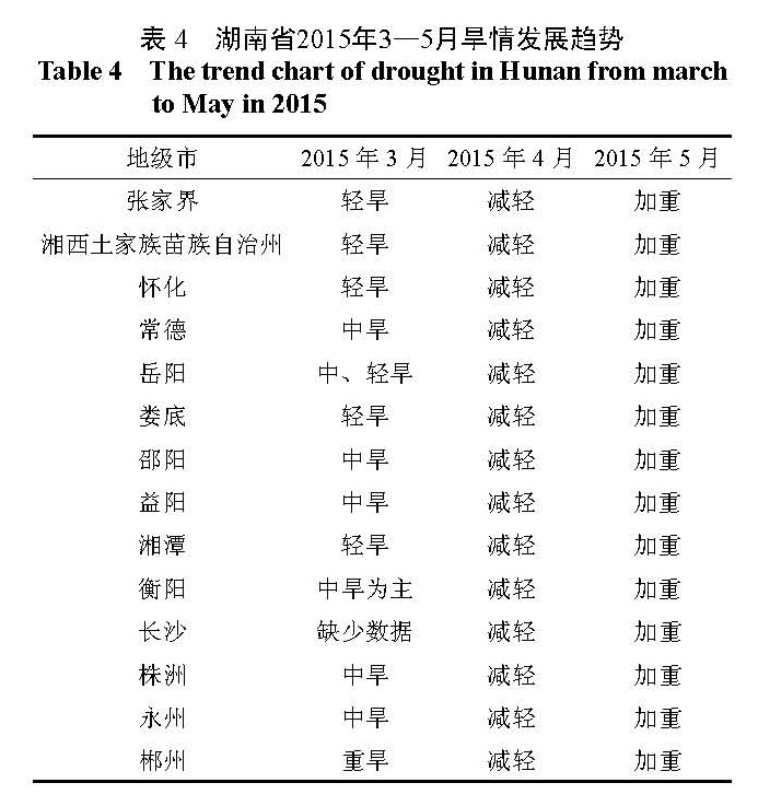
湖南省森林资源丰富,森林覆盖率达 47.77%,但森林资源质量不高,抗逆能力较差;旱灾和因旱灾引发的次生灾害可能会成为湖南林业发展的最大威胁。以 MODIS数据为数据源,提取林地干旱遥感监测因子的植被指数( NDVI)与地表温度( LST),利用温度植被干旱指数( TVDI)模型,并进行湖南省 2013—2015年森林植被生长季的林地干旱反演,分析得到 2013年湖南全境林地旱情从 3月到 8月发生不同程度的加重的现象,生长季前期干旱区域分布在湘南,湘西北地区出现干旱的程度较低;生长季后期洞庭湖区及湘中地区干旱程度较为严重。进一步反演 2014年和 2015年每年 3—5月林地干旱时空分异特点,在时间尺度上, 2015年 3—5月旱情有逐月加重趋势,与 2014年相比,其同比月份的干旱程度较高。在空间分布上,旱情较为严重的区域多分布在湘南和湘中的局部区域。将 2013年 8月湖南省气象局发布的干旱等级监测数据,与依照干旱反演得出的 TVDI值所确定的干旱等级进行比较,干旱等级的一致率达 81.4%,由此,随着湖南省卫星减灾应用工程不断完善,可以成为林地干旱监测预警的有效实现途径之一。
Hunan province is rich in forest resources, the coverage of forest of which has reached up to 47.77%,however,the quality of the forest resources is generally low and the ability of tolerating adversity is poor, drought and secondary disasters caused by drought may become the biggest threat to Hunan forestry development. Using the MODIS to extract the remote sensing monitoring factors of woodland drought, Normalized Difference Vegetation Index (NDVI) and Land Surface Temperature (LST),using the temperature vegetation drought index (TVDI) model,at the same time,inverting the woodland drought of forest vegetation growth season of Hunan province from 2013 to 2015.Analysis showed that the drought in hunan province has had different degrees of aggravation from march to August in 2013,the arid region is distributed in southern hunan in early stage of the growing season with the lower levels of drought in the north-western hunan.in addition, the severity of drought around the dongting lake and the central Hunan is more serious in the later stage of growing season. Further inverting the characteristics of woodland drought and spatiotemporal differentiation of 3-5 each year from 2014 to 2015, At the time scale, the drought has been increasing from march to May 2015 which was higher than in the previous month in 2014. In the spatial distribution, the regions with more severe drought conditions are distributed in local areas in southern hunan and central hunan.Comparing the drought monitoring gradational data of The weather bureau issued in hunan province of August 2013 with the level of drought determined by TVDI which is derived from the drought inversion,the uniformity of drought levels has reached up to 81.4%,therefore, with the continuous improvement of the application project of satellite disaster mitigation in hunan province, it can be one of the effective ways to realize the drought monitoring and early warning of forestland.


