基金项目:国家自然科学基金面上项目( 41574011);福建省自然科学基金面上项目( 2016J01199),福建省测绘地理信息科技创新项目(2015J14)
作者简介:何原荣,副教授,博士后; E-mail:heyuanrong@126.com
作者简介:何原荣,副教授,博士后; E-mail:heyuanrong@126.com
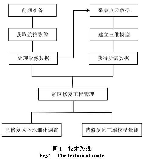
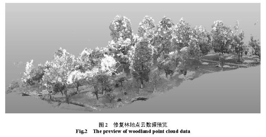
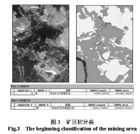
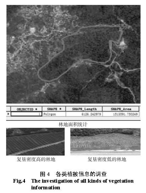
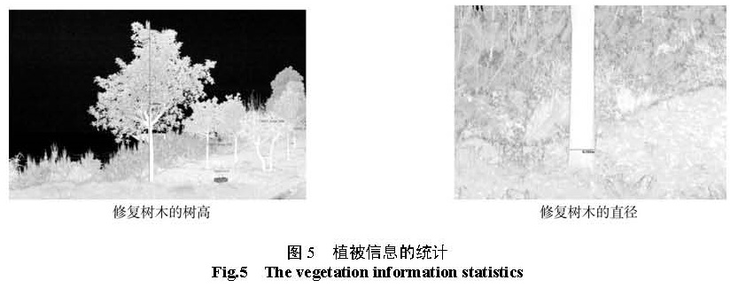
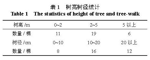
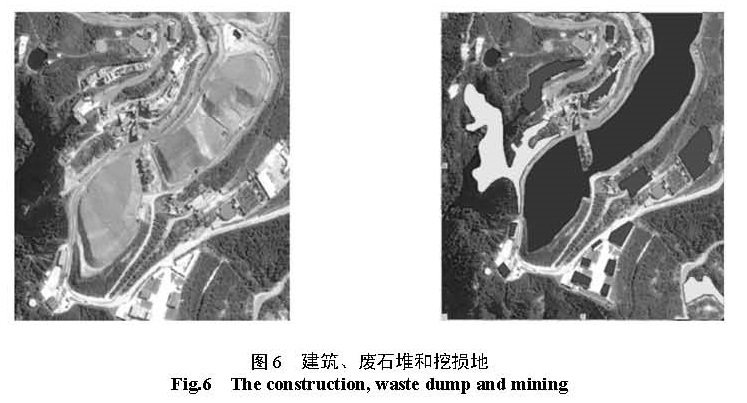
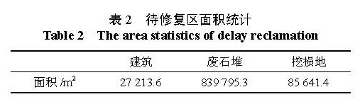
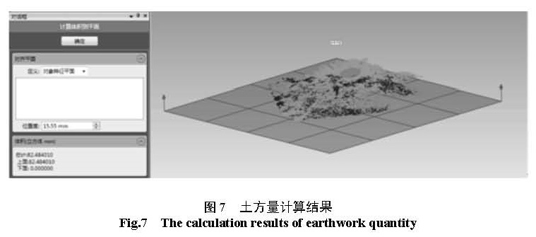
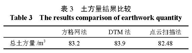
由于矿业开发强度高和规模大,以及在开矿过程里不注意维护好矿区的生态,目前矿区的生态维护承受着十分庞大的压力。为更好地对矿区进行生态修复,首先,本研究介绍矿区修复的基本内容及其效益,通过无人机像和三维激光扫描仪技术获取的航拍影像图和激光点云数据,阐述航拍影像与点云数据的获取流程和处理方式,将矿区生态修复采集的数据从二维拓展到三维;以矿区待修复区的测量分析和已修复区林地细化调查为案例,在 ArcGIS、南方 CASS、FAROscene和 GEOmagic等软件支持下,得矿区各类专题图和建立三维场景模型,为矿区生态修复提供技术和成果支撑。应用结果表明,航拍影像与点云数据在矿区生态修复中的应用,成效明显。
Due to the high mining development strength and scale, and in the process of mining don’t pay attention to the ecological safeguard mining area, the mining area ecological maintenance under enormous pressure.To better for the mining area ecological restoration, first of all, this paper introduces the basic content of mining area repair and benefit, by the unmanned aerial vehicle (UAV) and 3D laser scanner technology for aerial image and laser point cloud data, aerial images and the point cloud data acquisition process and approach, the data from the mining area ecological restoration from 2D to 3D;In the mining area to repair the measuring analysis and has been fixed area forest land detailed investigation for the case, such as ArcGIS, southern CASS, FAROscene and GEOmagic software support, mining area of thematic map and 3D scene model is set up, support for the mining area ecological restoration technology and achievements.Application results show that aerial images and point cloud data to the application of ecological restoration in mining area, effect obviously.

中南林业科技大学学报
《中南林业科技大学学报》原名《中南林学院学报》,是中南林业科技大学主办的以林为特色的自然科学学术期刊。该刊1981年创刊,2010变更为月刊,月底出版,国内外公开发行。国际刊号为ISSN 1673-923X,国内刊号为CN43-1470/S。该刊是教育部优秀科技期刊,全国优秀高校学报,湖南省一级期刊。是全国中文核心期刊,中国科学引文数据库来源期刊,中国精品科技期刊,中国科技核心期刊。该刊入编了国内所有的期刊数据库。
主要栏目:林学、生态学、生物科学与技术、植物学、园林、木材科学等。
读者对象:本刊适合于农林院校师生以及农林科研院所、农林管理部门和生产单位的科技和管理人员阅读,也适合于与以上学科和专业有关的其他高校师生和科技人员阅读。